The magazine thus included a two-page map – attempting to answer these larger cultural and evolutionary questions via cartography.
 [Image: A map of possible human migration routes out of Africa and the Middle East; via New Scientist].
"Until quite recently," the article tells us, "H. sapiens was thought to have evolved just 100,000 years ago. Over the past two decades, however, a consensus has grown that anatomically modern humans emerged in Africa at least 160,000, and possibly 200,000, years ago."
But how did humans spread?
- Skeletal remains from Skhul and Qafzeh in Israel dating from 120,000 to 90,000 years ago are the oldest known traces of modern humans outside Africa... However, all evidence of human habitation beyond Africa disappears around 90,000 years ago, only to emerge again much later.
Little details stand out. For instance: "The earliest evidence of settlement by modern humans in south Asia, comprises stone tools and human remains discovered in the Fa Hien and Batadomba Lena caves in Sri Lanka, dating from up to 35,000 years ago."
However – and I find this absolutely fascinating: "Although none of these artefacts is more than 35,000 years old, that may simply reflect the fact that sea levels are about 100 metres higher today than they were 50,000 years ago. Any artefacts or bones left by the first coastal migrants are now buried beneath the sea." (emphasis added)
But it's the map, I think, that tells the story so clearly. My only major problem with it is that it shows the world as it looks today, with sea levels where they stand in the present.
However, as we only just read, global sea levels were at least 100 meters (or 328 feet) lower back then, because so much water had been frozen into continent-spanning glaciers. Accordingly, the continents would have had very different outlines. Sri Lanka was not an island, for instance, but a peninsula connected to India, and many, many hundreds of smaller islands throughout Indonesia were actually connected into one large landmass.
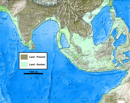 [Image: A map of southeast Asia during the Ice Age; note how much dry land there could have been. This certainly isn't the greatest map in the world; it's just all I could find – and it comes from a site claiming that this somehow proves Atlantis was real...].
Looking at a more accurate Ice Age geography, in other words, would make it substantially easier to comprehend how humans spread, for the most part on foot, to places as far away as central Australia. In fact, I'd go as far as to suggest that, until you look at the world as it was back then, with lower sea levels, you will only mis-theorize these migration routes, devising ever more elaborate forms of seafaring and stellar navigation when it might simply have been the case that they walked.
In any case, ancient human migrations just blow me away. What was it like, standing there on the sandy coasts of Iran or Saudi Arabia, 55,000 years ago? Walking around in the growing darkness as evening sets in, looking up at the stars, building fires – perhaps even dreaming of future towers on the very site where Dubai now rises.
[Note: If anyone knows where to find good maps of Ice Age coastlines, let me know!]
No comments:
Post a Comment