 [Image: From the "atlas of hidden water." Check out the original PDF or simply view it
 larger].
An "atlas of hidden water" has been created to reveal where the world's freshwater aquifers really lie. "The hope," New Scientist reports, "is that it will help pave the way to an international law to govern how water is shared around the world."
This prospective hydro-geopolitical legislation currently includes a "draft Convention on transboundary aquifers."
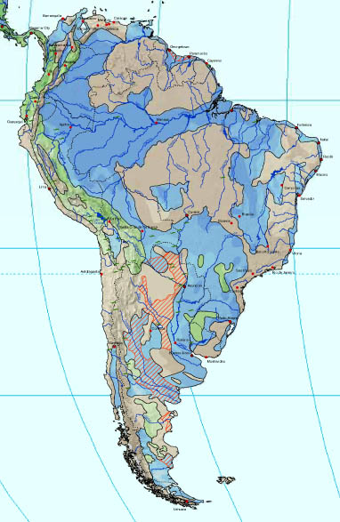 [Image: The "hidden water" of South America].
"What the UNESCO map reveals," New Scientist adds, "is just how many aquifers cross international borders. So far, the organisation has identified 273 trans-boundary aquifers: 68 in the Americas, 38 in Africa, 155 in Eastern and Western Europe and 12 in Asia." One of these is the Nubian Sandstone Aquifer System, whose waters are nearly a million years old.
According – somewhat oddly – to the International Atomic Energy Agency:
- The ancient system’s massive reserves, estimated at 375,000 cu km of water (equivalent to about 500 years of Nile River discharge), are confined deep inside the earth’s underground chambers – staggered, tiered, and pooled beneath the sands of the Sahara Desert, oasis settlements, wadis (dry riverbeds that contain water only during times of heavy rain), small villages, towns, and large cities.
A more detailed map is due out in 2009 – meanwhile, several more can be downloaded here.
No comments:
Post a Comment