Baarle-Hertog borders the Netherlands – but, because of its unique history of political division, the town is sort of marbled with competing national loyalties. In other words, pockets of the town are Dutch; most of the town is Belgian. You can thus wander from country to country on an afternoon stroll, as if island-hopping between sovereignties.
Check out the town map.
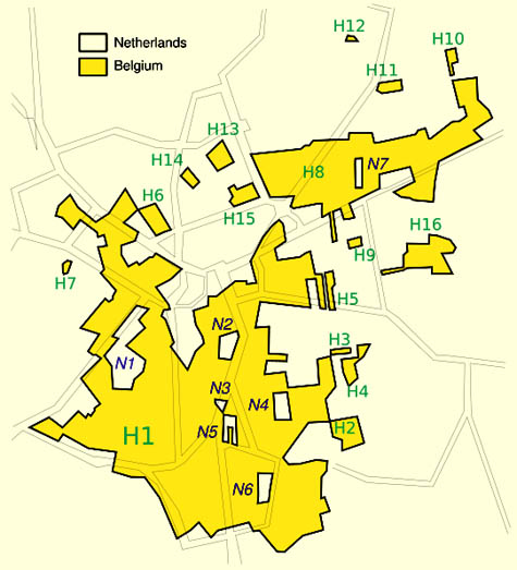 [Image: The strange, island-like spaces of micro-sovereignty within the town of Baarle-Hertog; a few more maps can be seen here, and you can read more in this two-page article].
Being in a bit of a rush at the moment, I'll simply have to quote Wikipedia:
- Baarle-Hertog is noted for its complicated borders with Baarle-Nassau in the Netherlands. In total it consists of 24 separate pieces of land. Apart from the main piece (called Zondereigen) located north of the Belgian town of Merksplas, there are twenty Belgian exclaves in the Netherlands and three other pieces on the Dutch-Belgian border. There are also seven Dutch exclaves within the Belgian exclaves. Six of them are located in the largest one and a seventh in the second-largest one. An eighth Dutch exclave lies in Zondereigen.
The border is so complicated that there are some houses that are divided between the two countries. There was a time when according to Dutch laws restaurants had to close earlier. For some restaurants on the border it meant that the clients simply had to change their tables to the Belgian side.
Another website, apparently drawing from the Michelin Guide to the Netherlands, explains the origins of Baarle-Hertog's bizarre geography: it can all be traced back to the 12th century, it seems, when the town was first divided. The northern half of the town became part of the Barony of Breda (later home to the Nassau family), and the southern half went to the Duke of Brabant (Hertog means Duke in Dutch).
But that same website also mentions this:
- The municipality limits are very complicated. Nowadays, each municipality has its city hall, church, police, school and post office. The houses of the two nationalities are totally mixed. They are identified by the shield bearing their number: the national flag is included on it.
In any case, also check out this site for more historical information.
While we're on the subject of micro-sovereignties, though, be sure to check out Neutral Moresnet, a tiny, politically independent non-state formed around a zinc mining operation in eastern Belgium. There's also Cospaia, "a small former republic in Italy" which "unexpectedly gained independence in 1440" after Pope Eugene IV sold the land it stood on. "By error," we read, "a small strip of land went unmentioned in the sale treaty, and its inhabitants promptly declared themselves independent."
The Free State Bottleneck, Åland Islands, and the Sovereign Military Order of Malta are all also worth checking out.
Finally, of course, I'd be remiss if I didn't point out BLDGBLOG's earlier interview with Simon Sellars, co-author of The Lonely Planet Guide to Micronations.
(With huge thanks to Scott Gosnell, Christopher, Claus Moser, and Blinde Schildpad for the tips!)
No comments:
Post a Comment